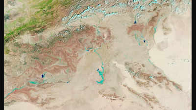
The Sahara Desert, known as one of the driest places on Earth, is witnessing an extraordinary transformation as heavy rainfall breathes life into its arid landscape. Following an extratropical cyclone that drenched parts of northwestern Africa on September 7 and 8, satellite images from NASA reveal surprising patches of greenery emerging in regions typically characterised by barrenness.
Countries such as Morocco, Algeria, Tunisia, and Libya are now showcasing traces of vegetation as shrubs and trees sprout in low-lying areas like riverbeds. Historically a lush environment with lakes, the Sahara has long been transformed by climatic changes. This unusual rainfall event, attributed to a shift in the tropical rain belt, raises questions about the impacts of climate change on rainfall patterns across Africa.
Heavy rainfall in the Sahara leads to vegetation growth
According to Sylwia Trzaska, a climate variability researcher at the Columbia Climate School, shrubs and trees are flourishing in low-lying areas such as riverbeds. Peter de Menocal, president of the Woods Hole Oceanographic Institution, explained that while it is uncommon, plant life can respond quickly to significant rain events in this part of Africa. During such episodes, the arid dunes can transform into lush, green expanses as plants capitalise on the newfound moisture.
Historically, the Sahara was once a verdant landscape dotted with vegetation and lakes, a reality that existed between 11,000 and 5,000 years ago, as suggested by de Menocal’s past research.
The recent deluge has even caused typically dry lakes to fill up, according to Moshe Armon, a lecturer at the Institute of Earth Sciences, Hebrew University of Jerusalem.
Satellite images of Sahara after rainfall
On September 10, the Moderate Resolution Imaging Spectroradiometer (MODIS) on NASA’s Terra satellite captured striking false-colour images of runoff and floodwater in the Sahara. The images, which combine visible and infrared light, reveal areas covered by water that appear in varying shades of dark and light blue. These shades reflect the depth of the water and the amount of suspended sediment.
Notably, the same region was dry and arid in images captured just a month earlier on August 14. Preliminary satellite analysis indicates that more than 200 millimetres of rainfall fell in the affected areas, a figure equivalent to the region’s annual precipitation. These rainfall accumulation estimates are derived from NASA’s Integrated Multi-Satellite Retrievals for GPM (IMERG) data, particularly useful due to the scarcity of ground-based rain gauges and radar stations in the region.
Armon further remarked on the remarkable sight of normally dry lakes filling up as a result of this event. Upon closer inspection of the satellite images, several of these lakes are visible as dark blue areas, including notable locations like Iriqui National Park in Morocco and Sebkha el Melah, a salt flat in central Algeria.
Also read: Hurricane Helene delays SpaceX’s Crew-9 launch, impacting Sunita Williams and Butch Wilmore’s return
